

PHOTO ARCHIVE – Hickory Ridge Lookout Tower, Hoosier National Forest – 2013-2026
If the view from the Hickory Ridge Lookout Tower isn’t the most spectacular on the Hoosier National Forest’s 204,000 acres, it’s unquestionably the most expansive.
Indeed, the 360-degree view from the tower cabin is reminiscent of our airborne approach to the Amazonian port city of Leticia Colombia — a canopy of green as far as the eye can appreciate.
Situated 21 road miles southeast from Bloomington on the southern cusp of the Charles C. Deam Wilderness, Old Hickory rises 110 feet above an 890-foot ridge top, just south of Lake Monroe’s southeastern shore. The panoramic view from the top encompasses Monroe, Lawrence, Jackson and Brown Counties.

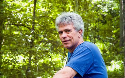
PHOTO ARCHIVE: Backyard Deer – Bryan Park, Bloomington, Ind. – 2015-2026
My relationships with urban deer began in my Herald-Times staff writer days in the late 1980s, when I discovered a New York Times Magazine article titled Rats with Hooves.
I first encountered white tail deer on the streets of Bloomington circa 2010 by the old Sarkes Tarzian estate, now called Deer Park. Legend has it that the town father imported a deer herd, which was the custom of the fabulously wealthy in the mid-20th century.
By 2015, their progeny had migrated to my back yard and were urbanized enough to pose for photographs.
I put this photo archive together after discovering a spotted fawn standing less than 10 feet behind me while I hand sanded a wood project.
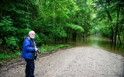
A Rainy Day Driving for Pleasure Through the Charles C. Deam Wilderness and Wildlands
I broke my two-week post-North Pole Photo Fast on a rainy day drive through the Deam Wildlands with two of my three oldest friends, guys I’ve known since 1969 and reconnected with the past few years: Tom Diaz and Pete Katsaros.
I also met my Limestone Post Revisiting the Deam column deadline by once again combining the personal and professional along the drive through the Charles C. Deam Wilderness and surrounding Wildlands in Monroe, Jackson, and Brown Counties.
College buddies, Tom, Pete, and I have gotten together two years in a row, this time with a plan to hike the Hoosier National Forest’s Pate Hollow Trail, which got washed out. So, we hit the back roads from Brooks Cabin to Elkinsville, a ghost town that was once “bathed in the shadow of Browning Mountain.”
Alta, Norway: A World Class Photo Stop on Top of the World — on the Altafjord
That the Photo Gods had blessed our 10-day adventure to Lapland was apparent every second of the journey, from the sun’s breakthrough the moment we crossed into the Arctic Circle from Rovaniemi, Finland, through a legitimate Photo Miracle in Alta, Norway.
Along the way, the sun and skies offered up a mutable array of light and form every day, from Finnish lake country to the Norwegian Sea to the Gulf of Finland, where our trip ended at Helsinki.
I chose Altafjord as the ultimate Photo Stop after concluding its 24-mile drive along the coast would offer abundant opportunities to capture world-class natural beauty in the Midnight Sun – and for the local Sami culture.
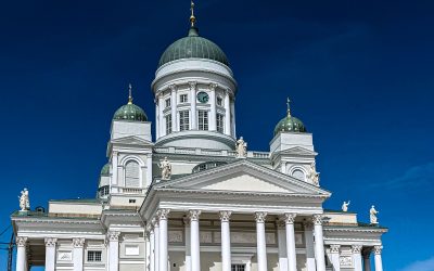
PHOTO ALBUM: Finland — Helsinki Architecture, Street Scenes, Gulf of Finland
Our expedition to Lapland and the Norwegian Sea ended with a day and a half exploring Helsinki on the Gulf of Finland.
From our Airbnb condo in the Töölö – the collective name for the city’s Etu-Töölö and Taka-Töölö neighborhoods north of the City Centre on the western side of the Helsinki Peninsula – we crisscrossed the city south to the Gulf’s far southern coast.
Along the way, near perfect weather illuminated the city’s architectural gems – Helsinki Cathedral, Uspenski Cathedral, Central Railway Station – statues, fountains, and street scenes. I shot but didn’t publish photos of cruise ships. Natural light bathed the National Library of Finland collections.
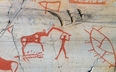
PHOTO ALBUM: Norway — Alta Museum Trail, 7,000-year-old Rock Art
The Alta Museum Trail encapsulates all that is world-class about Alta, Norway, from its scenic natural beauty to rock art created between 7,000 and 2,000 years ago by hunters and gatherers.
Our last trek in Scandinavia, the 2.5-mile trail traverses one of the world’s largest collections of prehistoric art – more than 6,000 carvings and paintings in five locations – and features breathtaking views of the Altafjord and Scandinavian Mountains.
The art depicts a variety of animals, including elk, reindeer, bears, birds, whales, and fish, as well as scenes of spiritual and daily life.
The carvings were discovered in the 1970s and, per the custom, were painted red to make them more visible. The paint is being removed to prevent damage to the rock surface.
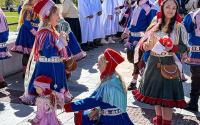
PHOTO ALBUM: Norway — A Sami Miracle in Alta
With a half century background in writing for the public, I have no qualms whatsoever calling what happened in Alta, Norway, on Saturday morning, May 30, 2026, a miracle.
From the moment I began planning this expedition to the Upper Arctic Circle, I knew a Photo Goal of capturing the indigenous Sami in traditional garb was a near impossibility. Fully aware when two women so adorned passed by the window of Kaffe Frida, our favorite coffee shop, I suggested a Northern Lights Cathedral Photo Stop a couple blocks up the plaza.
After shooting the world-class architectural marvel, the doors opened and a parade of Sami in traditional wear streamed out and filled the sidewalks, happy to be photographed after a confirmation ceremony that marked their first step toward adulthood.
Divine intervention for sure. I’m sticking with miracle.

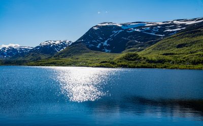
PHOTO ALBUM: Norway — Altafjord and the Scandinavian Mountains, Secret Arctic Paradise
After four Photo Stops on the Altafjord in three days, I’m confident saying it’s 24 miles of Scandinavian Mountain coastline is one of the world’s most underappreciated natural and cultural wonders.
DuckDuckGo searches for the Arctic inlet produced a decent collection of imagery. But it only generated one informational hit, a Wikipedia page that merely reports the fjord separates into two straits at the islands of Stjernøya and Seiland and empties into the Norwegian Sea. Throughout the 20th century, British historians referred to it as Altenfjord.
It would take more than four Photo Stops to find and capture the Midnight Sun image I imagined but did not find on this expedition. But the Travel Gods offered up an array of once-in-a-lifetime alternatives.
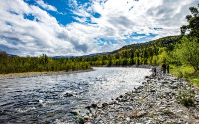
PHOTO ALBUM: Norway – Alta River, Alta
Alta on the Norwegian Sea was the penultimate destination for our 10-day journey to the Top of the World in the Arctic Lapland.
I chose Alta for its status as the northernmost city in the world with 15,000 residents and the 24-mile seaside photo drive it offered along the Altafjord, the one Photo Stop I went there for and couldn’t miss.
The GPS routed us from Kautokeino through the breathtaking Alta River Valley, where we picnicked at a rest stop on the riverside before settling into our penthouse Airbnb apartment in the heart of the city.
We immediately hit the fjord for the first of three days in pursuit of Arctic light and form in the Midnight Sun.

PHOTO ALBUM: Norway — Kautokeino, Capital of the Sami
Kautokeino, Norway, earned its place as a Lapland Photo Stop due to its status as the capital of Europe’s only indigenous people, the Sami, and its strategic location between the Pallas-Yllästunturi National Park in Finland and the Altafjord on the Norwegian Sea.
An estimated 85% of Kautokeino’s residents speak Sami as their first language. Their ancestors have occupied the Lapland regions of Norway, Sweden, Finland, and Western Russia for thousands of years.
The village of 2,800 sits on a scenic inland plateau, midway between Pallas and Alta, with flat and rolling plains bisected by the Alta River and boasts a reputation as the coldest inhabited area in Norway. January temperatures average -15C (5F).
The weather was perfect in May.
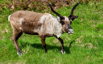
PHOTO ALBUM: Finland – Pallas-Yllästunturi National Park
The first Photo Stop on our journey to the Top of the World was the Pallas-Yllästunturi National Park, where we took a short hike through Finland’s third largest nature preserve and reputed home to the world’s cleanest air.
As we were on our way from Roveniemi, Finland, to Kautokeino, Norway, en route to our ultimate destination of Alta on the Norwegian Sea, we traversed the park’s shortest trail – the four-mile Varkaankuru Path loop from the Visitor Center.
Our brief experience confirmed the National Parks Association’s declaration: “Pallas-Yllästunturi National Park offers a unique blend of breathtaking Arctic landscapes, rich biodiversity, and cultural history, inviting visitors to explore and appreciate the serene beauty of Lapland.”

PHOTO ALBUM: Lapland Lake Region — From Rovaniemi in Finland to the Torne River at Pello, Sweden
The last leg of my Retirement Travel Trifecta stepped over the Arctic Circle as our Finnair jet made its final descent from Helsinki to the Rovaniemi Airport in Finland.
The Lapland Capital of 66,000 sits a couple miles south of the circle’s boundary line and served as our launchpad to the Trifecta’s northernmost destination another 300 miles north, altogether 6,000-plus miles from home. Our brief time in the city was spent sleeping and eating.
With an eye toward Sweden a little more than an hour to the west, we spent our first day in Finland exploring its scenic Lapland Region lake country between Rovaniemi and the Torne River at the Swedish border at Pello.
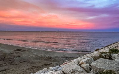
PHOTO ALBUM: Valencia, Spain – Sunset on the Mediterranean, Good bye in Villena
After checking out from our cabana in El Saler in Valencia, Patricia and I wheeled our luggage onto the bus and into a cab for a morning preview of the seaside Hotel SolPlaya, where two nights later I would spend my last few hours in Europe.
SolPlaya, which translates as SunBeach, has only a two-star rating, but the sole downside we found was that it had no restaurant or door to the beach. My room was clean and comfortable and cost $72 for the night.
The walk to the 2.2-mile-long stretch of Mediterranean sand that includes three beaches – Playa de las Arenas, Playa de la Malvarrosa and Playa de la Patacona – was literally one minute from the hotel door.

PHOTO ALBUM: Valencia, Spain – Old City, El Carmen, Central Market, Street Art, El Estrecho (the Narrow One)
On our second day in Valencia, we explored the Old City, in search of Europe’s biggest produce market, world-class street art, a Medieval city gate and the world’s once-second narrowest building.
Mercado Central has more than 1,200 stalls and eateries offering fresh fruits and veggies, along with meat, cheese, spices, nuts and seafood. El Carmen, a once-rundown neighborhood on the Old City’s north side, has a reputation for street art and quirky nightlife.
Vivid imagery and poignant messaging covered nearly every wall, fence, bridge and underpass in and around El Carmen.
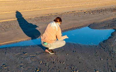
PHOTO ALBUM: Valencia, Spain – Sunrise on the Mediterranean Sea, El Saler, the City of Arts and Sciences
My creative heart started thumping as we passed the City of Arts and Sciences in the taxi on our way from the Valencia Airport to our cabana. We spent our first full day there, and to be honest, my chest still pounds when I think of it.
I can say with 100% confidence that Valencia’s City of Arts and Sciences is the most magnificent, non-natural subject I’ve ever captured on film or in digital data. Every 50 feet produced an image as or more intriguing than the last.
The City complex features multiple, striking structures that occupy a mile and a quarter of the five-mile Jardin del Turia, the Turia River’s natural riverbed.
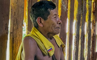
PHOTO ALBUM: Indígenas Huitoto, Last Colombian Amazon Photo Stop
For our last Amazonian adventure, our Ticuna guide Ramiro led our family entourage to a Huitoto village a half an hour or so north and west into the jungle, designated by a roadside sign as Indígenas Huitoto.
We toured the village’s agricultural plots, where Britannica says they practice “agroforestry,” a form of sustainable agriculture through which they integrate crops into the forest and mimic the ecosystem’s natural processes.
The Huitoto, with an estimated population of 8,500, are among 34 Amazon tribes that the Colombian Constitutional Court designates as at risk of extinction.
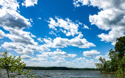
PHOTO ALBUM: On the Monroe Trail to Lake Monroe
I’ve been hiking what AllTrails calls the Monroe Trail for more than three decades but have never followed it to the lake of the same name.
I’ve always taken a side path to the now-history Waldrip Cabin when the old road-turned-trail heads 230 feet downhill nine-tenths of a mile to the shoreline. But since that trail is rapidly growing over and littered with storm damage, and it had been eight years since I photographed Lake Monroe, this time I veered right.
Indiana’s largest lake was high, quiet, and on the move with the wind under a picturesque blue sky filled with billowing cumulus clouds. The trail was mid-spring lush.
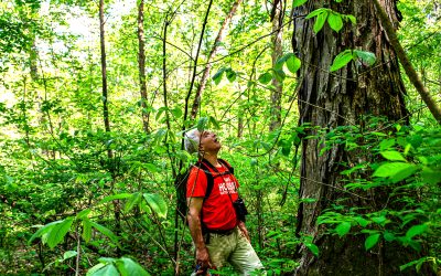
Envisioning the Deam Wildlands with Jeff Stant
It doesn’t take nine hours of bushwhacking through the Charles C. Deam Wilderness to imbibe Jeff Stant’s passion for the largest, wildest block of hardwood forestland in Indiana and the Lower Midwest.
“There’s nothing like it in Indiana,” he says, while pausing on a downed tree by a Saddle Creek feeder stream on the way to his favorite stand of old-growth hickories. “There’s really nothing like it in Ohio or Illinois. Nothing this large in terms of wild nature.”
But a five-mile, roundtrip trek on the Hayes Trail – with a mile or so bushwhack up Frog Pond Ridge and down through the Saddle Creek Valley – demonstrates that his passion is inspired by an intimate, tactile knowledge of the forest, all of which drive a grandiose vision.
PHOTO ARCHIVE: Hoosier National Forest – Waldrip Ridge – 2013-2026
I’ve titled the April Revisiting the Deam feature in Limestone Post after my original color photography muse Eliot Porter’s 1963 coffee table book The Place No One Knew: Glen Canyon on the Colorado.
Here’s the working lead to Waldrip Ridge: The Place No One Knew:
“Waldrip Ridge may indeed be the most beautiful and historic place in Southern Indiana that no one ever heard of. And after two hikes there exactly one year to the day apart – the latest with my friend and now fellow author Elaine Guinn – I can say definitively that Waldrip Ridge will in fact remain anonymous to anyone outside the fields of archaeology and Indiana history.”
The Southern Indiana-Northern Finland Connection: The Sami and Native Americans
To connect any dots between Southern Indiana and Northern Finland where we will be in six weeks, I had to trace back through 25,000 years of human history, give or take a few millennia.
When we drive in May along the Swedish border from Rovaniemi, Finland, to Alta, Norway, we will be in Lapland, the land of the Sami, Europe’s only indigenous population. At the Alta Museum, we’ll stand before rock art created by their Middle Stone Age ancestors some 7,000 years ago.
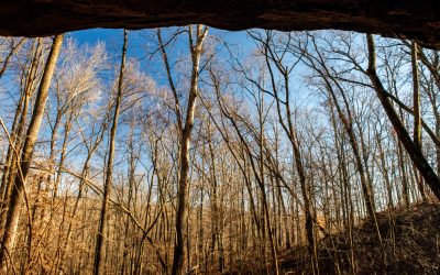
When I photographed the Rockhouse Hollow rock shelter in the Hoosier National Forest just up canyon from the Ohio River, I captured a scene that archaeologists say hunters and gatherers — who appear to be distant cousins to those original Scandinavian Laplanders — witnessed at that same time.
PHOTO ARCHIVE: Charles C. Deam Wilderness — Hayes Trail, 2015, 2016, 2017, 2026
After writing the story of Roscoe Hayes’s life in the Deam Wilderness – he ended up living in a hollow beech tree – I decided to return to the Hayes Trail, one of my favorite Hoosier National Forest treks.
While it was a perfect day for a hike, Hayes wasn’t quite brimming with photo opps. A few tiny violets, chickweeds, and seasonal waterfalls provided the only color and action, which left plenty of time for sitting on downed trees and an afternoon of deep thought in the deep woods.
That was best, as I’d just transferred photo albums from Hayes between 2016 and 2019 to the IU Archives and decided to create an online Hayes Photo Archive here.
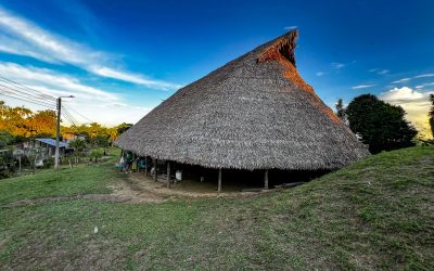
PHOTO ALBUM: With the Ticuna Indians in San Martin de Amacayacu, Upper Amazon River, Colombia
I’ve long maintained that I have the heart of an anthropologist, that had I taken anthropology for an elective freshman year instead of sociology, I might have had a different life; so, staying in the village of San Martin de Amacayacu with a few hundred Ticuna Indians was a pinnacle life experience.
No roads, no cars in the village or surrounding river communities, just a few hundred indigenous Amazonians living their lives in the jungle, some three miles up the Rio Amacayacu, selling arts and essentials to ecotourists, washing clothes in the river, playing soccer, and hanging out in the maloca.
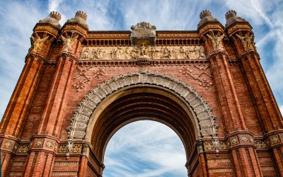
PHOTO ALBUM: Barcelona – Beauty by the Mediterranean Sea, Las Ramblas, Arc de Triompf, Port Vell, La Sagrada Familia
Spending two days exploring Barcelona with Patricia and Luz as my guides to one of the world’s great cities was a magical experience.
It was the only time during my week and a half in Spain that I and the “girls” – whom I hadn’t seen since they were teenagers 46 years prior – spent time alone, and the photo stops couldn’t have been any better.
In the Passeig de Gràcia fashion district, a model heard my camera click from behind on a wide angle shot, copped a pose, and looked at me as we passed as if to say, “Did you get the shot?” Thumbs up.
Introducing Jeff Stant: At the Grassroots Forest Forum on the Roadless Rule
As I count the days to my three-quarter-century mark, the life circles grow ever larger. Since August, I wrote a book about one character from the dawn of my professional career in 1985; and I wrote a column about a hike with another.
On Saturday, I will introduce Jeff Stant as the featured speaker at a Grass Roots Forest Forum at the Monroe County Public Library. He will talk about wilderness in Indiana.
I met Jeff in that very building in 1981, after he spoke about wilderness in Indiana and recruited me to be the Upland Group Sierra Club’s newsletter editor – my maiden journalistic experience.